Page Not Found
Page not found. Your pixels are in another canvas.

A list of all the posts and pages found on the site. For you robots out there is an XML version available for digesting as well.
Page not found. Your pixels are in another canvas.
About me
This is a page not in th emain menu
Published:
This post will show up by default. To disable scheduling of future posts, edit config.yml and set future: false.
Published:
This is a sample blog post. Lorem ipsum I can’t remember the rest of lorem ipsum and don’t have an internet connection right now. Testing testing testing this blog post. Blog posts are cool.
Published:
This is a sample blog post. Lorem ipsum I can’t remember the rest of lorem ipsum and don’t have an internet connection right now. Testing testing testing this blog post. Blog posts are cool.
Published:
This is a sample blog post. Lorem ipsum I can’t remember the rest of lorem ipsum and don’t have an internet connection right now. Testing testing testing this blog post. Blog posts are cool.
Published:
This is a sample blog post. Lorem ipsum I can’t remember the rest of lorem ipsum and don’t have an internet connection right now. Testing testing testing this blog post. Blog posts are cool.
Interactive maps for regional sea-level budget, based on pattern detection algorithms. 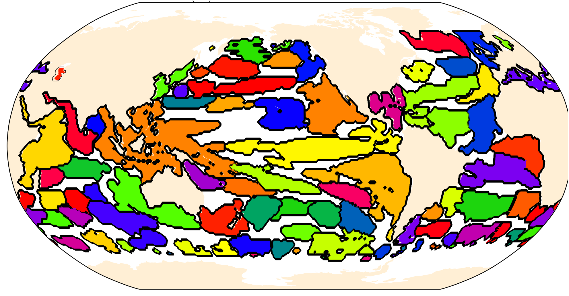
Published in JGR Oceans, 2020
This paper is about the drivers of regional sea-level change on the Northwestern European Shelf
Recommended citation: Hermans, T. H. J., Le Bars, D.,Katsman, C. A., Camargo, C. M. L.,Gerkema, T., Calafat, F. M., et al. (2020). Drivers of interannual sea level variability on the northwestern European shelf. Journal of Geophysical Research: Oceans,125, e2020JC016325. https://doi.org/10.1029/2020JC016325 https://agupubs.onlinelibrary.wiley.com/doi/full/10.1029/2020JC016325
Published in JGR Oceans, 2020
This paper is about regional and global steric sea-level change (temperature and salinity driven) during the satellite altimetry era
Recommended citation: Camargo, C. M. L., Riva, R. E. M.,Hermans, T. H. J., & Slangen, A. B. A. (2020). Exploring sources of uncertaintyin steric sea‐level change estimates. Journal of Geophysical Research:Oceans,125, e2020JC016551. https://doi.org/10.1029/2020JC016551 https://agupubs.onlinelibrary.wiley.com/doi/full/10.1029/2020JC016551
Published in Journal of Physical Oceanography, 2021
This paper is about the effect of oceanic wake in Madeira island (Portugal).
Recommended citation: Azevedo, C. C., Camargo, C. M. L., Alves, J., & Caldeira, R. M. A. (2021). Convection and Heat Transfer in Island (Warm) Wakes, Journal of Physical Oceanography, 51(4), 1187-1203. https://doi.org/10.1175/JPO-D-20-0103.1 https://journals.ametsoc.org/view/journals/phoc/51/4/JPO-D-20-0103.1.xml
Published in Journal of Climate, 2022
This paper is about the seasonal differences in sea-level projections.
Recommended citation: Hermans, T. H. J., Katsman, C. A., Camargo, C. M. L., Garner, G. G., Kopp, R. E., & Slangen, A. B. A. (2022). The Effect of Wind Stress on Seasonal Sea-Level Change on the Northwestern European Shelf, Journal of Climate, 35(6), 1745-1759. https://doi.org/10.1175/JCLI-D-21-0636.1 https://journals.ametsoc.org/view/journals/clim/35/6/JCLI-D-21-0636.1.xml
Published in Earth System Dynamics, 2022
This paper is about the contribution of Antarctica, Greenland, glaciers and terrestrial waterstorage to regional sea-level change.
Recommended citation: Camargo, C. M. L., Riva, R. E. M., Hermans, T. H. J., and Slangen, A. B. A.: Trends and uncertainties of mass-driven sea-level change in the satellite altimetry era, Earth Syst. Dynam., https://doi.org/10.5194/esd-13-1351-2022, 2022. https://esd.copernicus.org/articles/13/1351/2022/
Published in Cambridge Prisms, 2022
Short review of evolution of IPCC AR5 and AR6 sea-level projections
Recommended citation: Slangen, A.B.A., Palmer, M.D., Camargo, C.M.L., Church, J.A., Edwards, T.L., Hermans, T.H.J., Hewitt, H., Garner, G.G., Gregory, J.M., Kopp, R.E., Santos, V.M., \& van de Wal, R.S.W. : The evolution of 21st century sea-level projections from IPCC AR5 to AR6 and beyond, Cambridge Prisms: Coastal Futures, 1-33, doi: https://doi.org/10.1017/cft.2022.8, 2022. https://doi.org/10.1017/cft.2022.8
Published in Ocean Science, 2023
This paper is closes the regional sea-level budget from 1993-2016, in regions delineated with machine learning techniques.
Recommended citation: Camargo, C. M. L., Riva, R. E. M., Hermans, T. H. J., Schütt, E. M., Marcos, M., Hernandez-Carrasco, I., and Slangen, A. B. A.: Regionalizing the sea-level budget with machine learning techniques, Ocean Sci., 19, 17–41, https://doi.org/10.5194/os-19-17-2023, 2023 https://doi.org/10.5194/os-19-17-2023
Published in Frontiers for Young Minds, 2023
Paper for kids about natured-based solutions
Recommended citation: van Hespen, R., van Bijsterveldt, C.E.J., Camargo, C.M.L., Stoorvogel, M.M., & Bouma, T.J.: How Can Nature Protect People Against Sea-Level Rise?, Frontiers for Young Minds, 11:910803. https://doi.org/10.3389/frym.2023.910803, 2023. https://doi.org/10.3389/frym.2023.910803
Published in Frontiers in Marine Science, 2023
Non-linear sea-level trends in the Mediterranean Sea
Recommended citation: Meli, M., Camargo, C.M.L., Olivieri, M., Slangen, A.B.A., & Romagnoli, C. (2023). Sea-level trend variability in the Mediterranean during the 1993-2019 period. Frontiers in Marine Science, 10. doi:10.3389/fmars.2023.1150488. https://doi.org/10.3389/fmars.2023.1150488
Published in Geophysical Reserach Letters, 2024
Relationship between Shelbreak Jet and coastal sea-level variability
Recommended citation: Camargo, C.M.L., Piecuch, C.G., Raunbenheimer, B. (2024). From the Shelfbreak to Shoreline: Coastal Sea Level and Local Ocean Dynamics in the Northwest Atlantic. Geophysical Research Letters, 51(14). doi:10.1029/2024GL109583 https://doi.org/10.1029/2024GL109583
Published in Geophysical Reserach Letters, 2025
Study of major floods in the south of Brazil (May 2024) with multi-sensor approach, including new satellite SWOT
Recommended citation: Simoes-Sousa, I. T., Camargo, C. M. L., Tavora, J., Piffer-Braga, A., Farrar, J. T., & Pavelsky, T. M. (2025). The May 2024 flood disaster in southern Brazil: Causes, impacts, and SWOT-based volume estimation. Geophysical Research Letters, 52, e2024GL112442. https://doi.org/10.1029/2024GL112442 https://agupubs.onlinelibrary.wiley.com/doi/10.1029/2024GL112442
Published in Cambridge Prisms: Coastal Futures., 2026
Study comparing regional sea-level observations from 2007-2022 with IPCC AR5 projections.
Recommended citation: Camargo, C. M. L., Malagón-Santos, V., Cheen, J., Oerlemans, B., & Slangen, A.B.A. (2026). A comparison between regional sea-level projections and observations. Cambridge Prisms: Coastal Futures. Published online 2026:1-13. doi:10.1017/cft.2026.10023 https://doi:.org/0.1017/cft.2026.10023
Non-research articles that academics should read
Links to code and data created during PhD
Interactive maps for regional sea-level budget, based on pattern detection algorithms.
Photographies illustrating climate change
See here
Videos explaining scientific results in a simple and fun way.
See here
Published:
The steric component of sea-level change comprises variations in the temperature (thermosteric) and salinity (halosteric) of the oceans, which alter the water’s density, leading to volumetric variations of the water column. Although its importance is unarguable, throughout the literature there is a disagreement on how much the steric component actually contributes to sea-level change.
Published:
“Ocean mass variation is one of the main drivers of present-day sea-level change (SLC). Also known as barystatic SLC, those fluctuations are due to the melting of continental ice from glaciers and ice sheets, and variations in landwater storage. While a large number of studies have quantified the contribution of barystatic SLC to global mean SLC, fewer works have looked into how much ocean mass has contributed to regional SLC. Besides, most of the regional studies have focused only on the effect of one of the components (e.g., melt from Antarctica), or on the period and results of the GRACE satellite mission (since 2002). This work aims at providing a comprehensive analysis of global and regional barystatic SLC since 1993. For that, we collect a suite of estimates of the individual freshwater sources, namely the Antarctic and Greenland ice sheets, glaciers and terrestrial water storage. We then use them as input on the sea-level equation to obtain regional patters (fingerprints) of barystatic SLC, and validate our results by comparing the individual estimates with the values obtained from GRACE products. We finalize our analysis by looking into trend uncertainty patterns related to each contribution.”
Published:
“Understanding the drivers of present-day sea-level change is vital for improving sea-level projections and for adaptation and mitigation plans against sea-level rise. Sea-level budget (SLB) studies focus on attributing the observed sea-level change to its different drivers (steric and barystatic changes). While the global mean SLB is closed, explaining the drivers of sea-level change on a finer spatial scale leads to large discrepancies. Recent studies have shown that closing the regional budget on a regular 1x1˚ grid is not possible due to limitations of the observations itself, but also due to the spatial patterns and variability of the underlying processes. Consequently, the regional budget has been mainly analyzed on a basin-wide scale.
Published:
In comparison with the number of tide gauges measuring in-situ sea-level change along the Northern Hermisphere coastlines, the Southern Hemisphere has a poor spatial distribution of stations. For example, along the South American Atlantic coastline, only 12 tide gauges are registered at the Permanent Service for Mean Sea-level (PSMSL), of which only two have been updated in the last three years. While satellite altimetry can be used to provide data in locations where there is no in-situ data, estimating coastal sea-level change using altimetry data is challenging due to the distortion of the satellite signal close to the land. Consequently, sea-level change along the South American Atlantic coastline is still poorly understood. Here, we fill this gap by using coastal altimetry products together with a new network of tide gauges deployed along the coast of Brazil (by the SIMCosta project). Via a sea-level budget analysis, we look at the regional drivers of sea-level change along the coast.
Published:
IThe US East Coast is a heavily populated region, and models project that it will experience faster-than-global rates of sea-level rise in the coming century. Hence it is important to understand the underlying causes of sea-level variability. Along the US East Coast, an important driver of coastal sea-level variability is ocean dynamics, related to both large-scale circulation, such as the Gulf Stream, and also smaller local ocean currents. A relevant circulation feature in this region is the Shelf break jet (SBJ). The SBJ flows equatorward from the Labrador Sea towards the Gulf Stream at Cape Hatteras following the shelf break along the Northeast US coast. Here, we use 7 years of velocity data from the Ocean Observatory Initiative (OOI) Coastal Pioneer Array, together with tide-gauge data from 2014-2022 to establish the connection between coastal sea level and local ocean circulation over the shelf and the slope. Located at the New England shelf break, about 75 nautical miles south of Martha’s Vineyard, the Array has seven site moorings, spread from the shelf to offshore of the shelf break. Each mooring contains, among other instruments, an upward-looking ADCP, which measures three-dimensional velocities throughout the water column
Published:
The US East Coast is a heavily populated coastline, and models project that it will experience faster-than-global rates of sea-level rise in the coming century. Sea level changes due to several factors, such as ocean thermal expansion, melting of land ice, and ocean dynamics. The latter is one of the least well-known sea-level components. While several studies have shown a relationship between Gulf Stream transport and coastal sea level South of Cape Hatteras, such causal linkage to large-scale open-ocean circulation has not been shown for coastal sea level North of Cape Hatteras, possibly because coastal sea level here is more strongly related to local circulation over the shelf and the slope. Here we use 7 years of hourly velocity data from the Ocean Observatory Initiative (OOI) Coastal Pioneer Array to test this hypothesis. The Array is located at the New England shelfbreak ~75 nautical miles south of Martha’s Vineyard, and is composed of seven site moorings, spread from the shelf to offshore of the shelf break. Each mooring contains, among other instruments, an upward-looking ADCP, which measures three-dimensional velocities throughout the water column. This unique dataset, together with the dense network of coastal tide gauges, allows for a great case study of coastal sea level and local ocean dynamics.
Published:
According to NOAA’s Annual High Tide Flooding Outlook [1], the number of high-tide flooding days along the US East coast has increased rapidly in recent years. High-tide flooding, also known as nuisance flooding, identifies floods that can occur in the absence of storms, for example, simply due to above-normal water levels.. Due to sea-level rise, it is predicted that, by 2050, coastal communities across the U.S. will experience high-tide flooding on average 45 to 85 days per year. Predicting the frequency of future coastal flooding is vital for the development and maintenance of coastal cities. Here we discuss the role of local ocean dynamics to coastal flooding.
MSc course (Guest), Ocean topography and sea-level change, 2019
BSc Course, Climate Impacts and Engineering course, 2020
BSc Minor (Guest), Speculating the Future, 2020
Guest lecturer at the “Speculating the Future” course, on the topic of “The Value of the Oceans and Sea-level Change”.
MSc Thesis Supervision, Marine Environment and Resources Eramus MSc, 2021
MSc Intern Supervision, MSc Umweltgeographie und – management, Kiel University, 2021